How MyFarmWeb Seeks To Enhance Data Usage In Agriculture
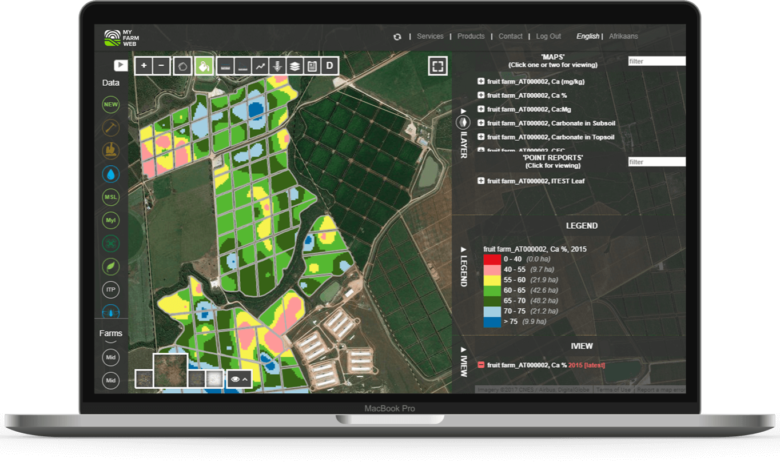
How MyFarmWeb Seeks To Enhance Data Usage In Agriculture. MyFarmWeb is an interactive, cloud-based platform, accessed through any browser, for storing, visualizing and comparing all types of maps, geographic and IoT generated agricultural data.
MyFarmWeb collates data into commercially workable information from disparate sources and interfaces various layers in relation to each other to make more informed decisions.
Companies can be able to:
- View soil physical characteristic maps, including the soil form maps with crop potential differences, plant-available water capacity, effective root depth, possible anaerobic conditions, management practice recommendations, representative soil moisture probe positions, and variable seeding and fertilisation maps.
- View your mapping through a grid pattern, the nutritional status and topography of your soil, including corrective and variable liming and fertilisation maps.
- Use the comparing tool to compare multiple maps in a single view and do in-depth analysis.
- View your personal weather station data or open source weather, as well as national dam levels on MYFARMWEB™ (only South African national dams are currently availible).
- View Precision Pest Monitoring on a weekly basis, enabling you to make quick, informed decisions. View and analyse historical incidence of pests and notice trends.
MYFARMWEB™ Mobile is the full mobile version of MYFARMWEB™ available on Andriod and IoS smartphone devices. It enables access to all farm generated maps and point data for single-layer analysis and in-field orientated decision making through smartphone GPS functionality. This mobile platform enables access to farmer-data almost anywhere and also boasts off-line capability for pre-synced information in areas with limited connectivity.
MYFARMWEB™ Capture is a cloud-based mobile data collection and visualization application used to collect infield precision samples on a GPS enabled smartphone or tablet. Used by farmers, agents, field- technicians and scouts to collect and interpolate soil, leaf and water sample data.